![]()
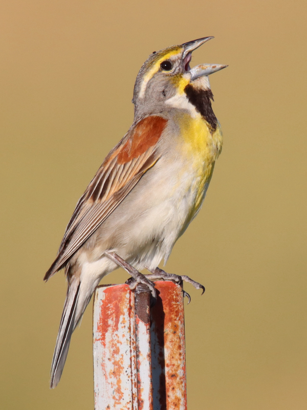
The arrival of migrating songbirds, flycatchers, hummingbirds, and shorebirds across America peaks from the last week of April to the last week of May (Dickcissel photo by Paul Konrad).
![]()
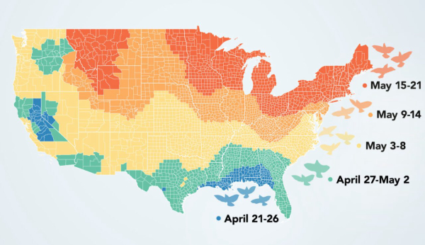
The BirdCast project mapped out the weeks of peak spring bird migration, defined as the periods with the highest nightly average of aerial bird density, using data collected from 143 radar systems from coast to coast (map by Audrey Carlsen, data analysis by Adriaan Dokter, migration data from BirdCast and eBird).
![]()
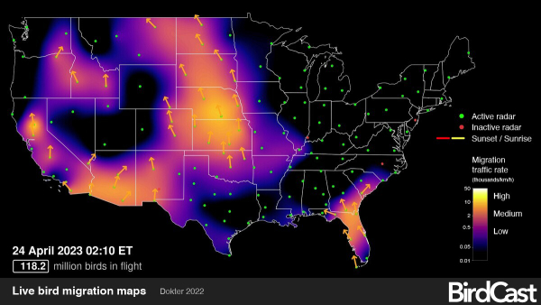
A stop-action look at the live BirdCast Map for very early Monday morning, April 24. It’s exciting to refer to the wealth of BirdCast information in advance of birding plans, and afterward too.
|
The timing of spring migration varies across the United States and even within regions and individual states according to radar data analyzed by BirdCast. Eager birders in the West will be able to enjoy their peak bird migration bonanza this week and next, during late April and the first week of May, while birders in the Northeast and Upper Midwest will need to be patient a few more weeks according to a new BirdCast analysis that mapped out the periods of highest migration density across the United States from March to June.
BirdCast is a collaboration among researchers at the Cornell Lab of Ornithology, Colorado State University, and the University of Massachusetts at Amherst that uses weather radar and machine learning to track and forecast bird migration. BirdCast has been monitoring nightly bird migration with the aid of weather radar across the United States since 1999. The newest analysis determined the peak periods of spring bird migration across the continental United States: Defined as when the nightly average of birds in the night sky was greatest, as measured by 143 radar systems from coast to coast, with each radar measuring aerial bird densities every 10 minutes from 2013 to 2022.
BirdCast senior researcher Adriaan Dokter at the Cornell Lab, explained that differences in bird migration timing can be seen not just across the continent, but even within some regions. “One thing that stood out to me is how the western Gulf of Mexico and Texas has a later peak migration date than the eastern Gulf,” said Dokter, noting that the difference is driven by the species composition of birds migrating in those 2 areas.
He added: “By far the most long-distance migrants, birds such as warblers and orioles, that are migrating from wintering ranges in Central and South America arrive in the United States in the western Gulf states and through Mexico, and way fewer arrive in the East. The Southeast is the main region where lots of common short-distance migrants winter, such as sparrows and blackbirds, and these birds migrate several weeks earlier.”
Dokter explained that the same pattern plays out in California’s Central Valley, where there is an ‘island’ of wintering range for short-distance migratory birds surrounded by the flight paths of long-distance migratory birds. He also pointed out that a corridor from western Texas north to the Dakotas registers relatively earlier peak bird-migration periods compared to surrounding areas. “It’s nice to highlight that the Great Plains are a main highway for migration, where birds enter the country, move north, and then distribute west and eastward,” he added.
While weather radar scans can’t be used to identify the bird species on the move (radar just detects the biomass of birds in the air), another project by some of the scientists involved with BirdCast is delving deeper into bird migration patterns. A study published in January in the journal Methods in Ecology and Evolution, spearheaded by researchers at UMass Amherst and the Cornell Lab, describes a new machine-learning computer model called BirdFlow that shows exactly which species are going where during their migrations.
BirdFlow processes multiple data sources by combining weekly estimates of bird numbers from eBird data provided by birders with previous studies of birds fitted with satellite-tracking tags to accurately predict the movements of particular bird species from location to location, week to week throughout their migrations.
“With BirdFlow we will be able to unravel the routes that birds take, from their nesting range to migration stopover locations to their wintering range, and back, without having to capture birds and attach tracking devices,” Dokter explained. “Understanding these connections will be critical to learning why some bird populations are doing poorly and some are doing well.”
You can access BirdCast its exciting live migration maps, along with migration forecasts, and previous nightly migration maps at BirdCast
To refer to the original article sourced in the Spring issue of Living Bird magazine, see When Will Spring Bird Migration Hit Its Peak? BirdCast Has Answers | All About Birds All About Birds